
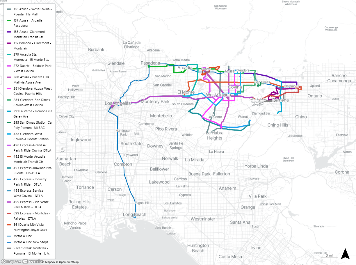
Foothill Transit And Metro Rail
Learn about transferring between Metro Rail and Foothill Transit buses, and see where your connections can take you.
Rail and bus connections work together for you!
We know having options to get around is important to you. That’s why we connect directly to many Metro Rail stations. The Metro A Line travels from Pomona into downtown Los Angeles where you can transfer to other Metro Rail Lines, and then continues all the way to Long Beach.
1. Pico Station
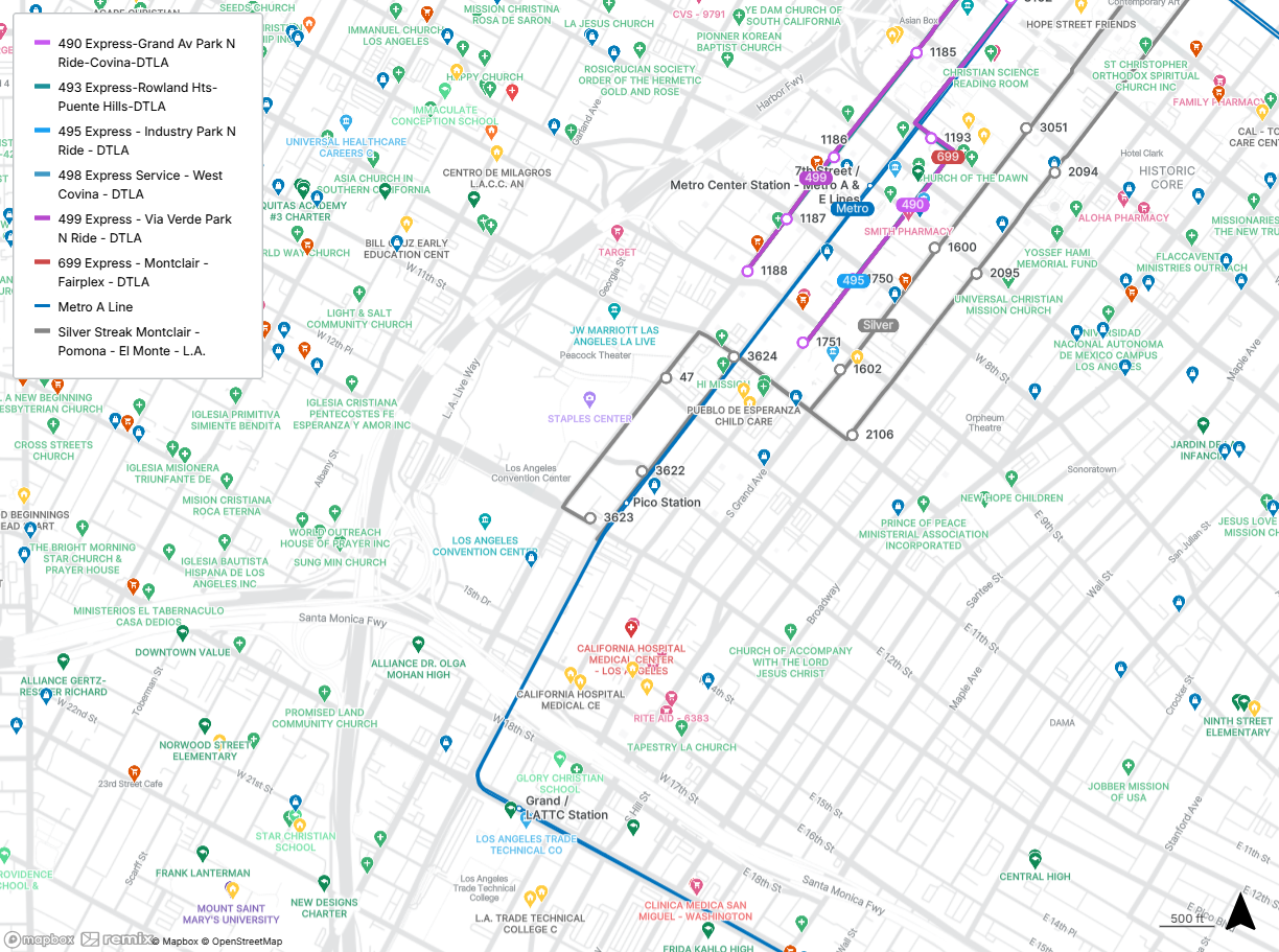
The Pico station is northwest of Pico Blvd and Hope St in downtown Los Angeles.
While you’re here, catch a concert or game at Crypto.com Arena or a performance at Peacock Theater, take a stroll through concerts of the past at the GRAMMY Museum, or browse the Social District Farmers’ Market.
Connect with the Silver Streak at Flower St and 12th St or Pico Blvd and Flower St. Connect with Lines 490, 493, 495, 498, 499, and 699 at Figueroa St and 9th St or Hope St and 9th St.
The Silver Streak serves Montclair, Pomona, West Covina, Baldwin Park, El Monte, and Los Angeles 24 hours a day, seven days a week. Popular destinations include Cal Poly Pomona and Plaza West Covina. Lines 490, 493, 495, 498, 499, and 699 travel into downtown Los Angeles on weekday mornings and back east on weekday evenings. Line 490 serves Glendora and Covina, including Glendora Promenade. Line 493 serves Rowland Heights and City of Industry, including Schabarum Park. Line 495 serves City of Industry. Line 498 serves West Covina. Line 499 serves the Via Verde Park & Ride. Line 699 serves Montclair and Pomona.
2. 7th St/Metro Center Station
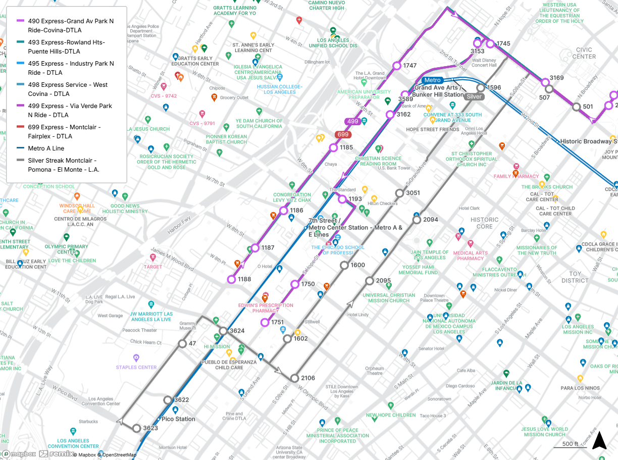
The 7th St/Metro Center station is at Flower St and 7th St in downtown Los Angeles.
While you’re here, browse the shopping and dining at FIGat7th, climb the Bunker Hill Steps, or stroll through Pershing Square.
Connect with the Silver Streak at Grand Ave and 7th St or Olive St and 7th St. Connect with Lines 490, 493, 495, 498, 499, and 699 at Figueroa St and 7th St or 6th St and Hope St.
The Silver Streak serves Montclair, Pomona, West Covina, Baldwin Park, El Monte, and Los Angeles 24 hours a day, seven days a week. Popular destinations include Cal Poly Pomona and Plaza West Covina. Lines 490, 493, 495, 498, 499, and 699 travel into downtown Los Angeles on weekday mornings and back east on weekday evenings. Line 490 serves Glendora and Covina, including Glendora Promenade. Line 493 serves Rowland Heights and City of Industry, including Schabarum Park. Line 495 serves City of Industry. Line 498 serves West Covina. Line 499 serves the Via Verde Park & Ride. Line 699 serves Montclair and Pomona.
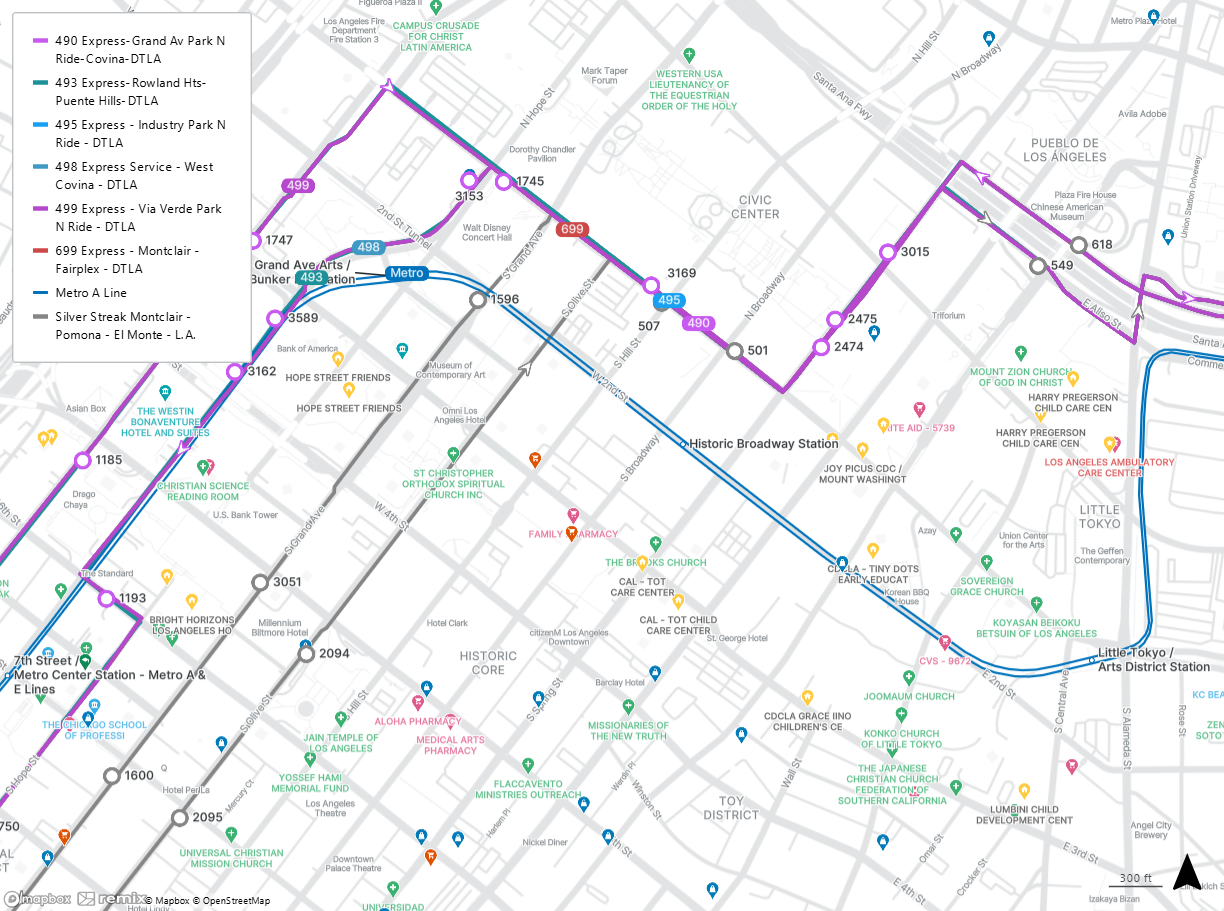
3. Grand Av Arts/Bunker Hill Station
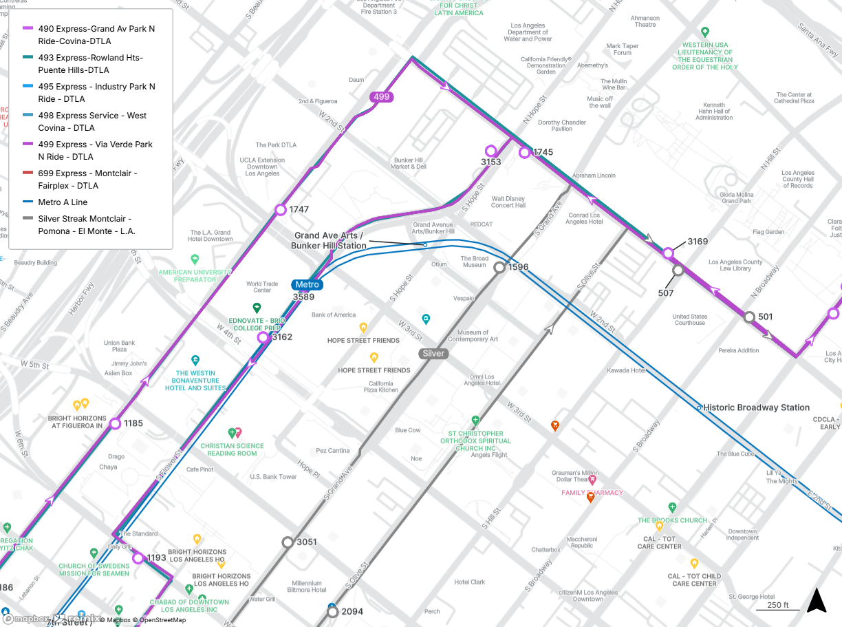
The Grand Av Arts/Bunker Hill station is at Flower St and 2nd St in downtown Los Angeles.
While you’re here, enjoy the contemporary art at The Broad, see a slice of movie history at the Bradbury Building, and have some fun(icular) on the Angels Flight Railway.
Connect with the Silver Streak at Grand Ave and 2nd St or Olive St and 5th St. Connect with Lines 490, 493, 495, 498, 499, and 699 at Figueroa St and 3rd St or Hope St and 1st St.
The Silver Streak serves Montclair, Pomona, West Covina, Baldwin Park, El Monte, and Los Angeles 24 hours a day, seven days a week. Popular destinations include Cal Poly Pomona and Plaza West Covina. Lines 490, 493, 495, 498, 499, and 699 travel into downtown Los Angeles on weekday mornings and back east on weekday evenings. Line 490 serves Glendora and Covina, including Glendora Promenade. Line 493 serves Rowland Heights and City of Industry, including Schabarum Park. Line 495 serves City of Industry. Line 498 serves West Covina. Line 499 serves the Via Verde Park & Ride. Line 699 serves Montclair and Pomona.
4. Historic Broadway Station
The Historic Broadway station is at Broadway and 2nd St in downtown Los Angeles.
While you’re here, enjoy the contemporary art at The Museum of Contemporary Art, Los Angeles, take a green break at Gloria Molina Grand Park, and view the iconic Los Angeles City Hall.
Connect with the Silver Streak and Lines 490, 493, 495, 498, 499, and 699 at 1st St and Hill St.
The Silver Streak serves Montclair, Pomona, West Covina, Baldwin Park, El Monte, and Los Angeles 24 hours a day, seven days a week. Popular destinations include Cal Poly Pomona and Plaza West Covina. Lines 490, 493, 495, 498, 499, and 699 travel into downtown Los Angeles on weekday mornings and back east on weekday evenings. Line 490 serves Glendora and Covina, including Glendora Promenade. Line 493 serves Rowland Heights and City of Industry, including Schabarum Park. Line 495 serves City of Industry. Line 498 serves West Covina. Line 499 serves the Via Verde Park & Ride. Line 699 serves Montclair and Pomona.
5. Little Tokyo/Arts District Station
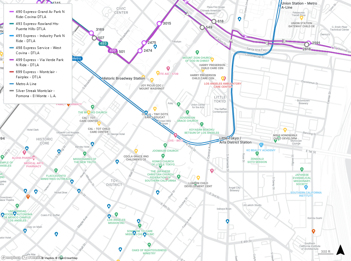
The Little Tokyo/Arts District station is at 1st St and Alameda St in downtown Los Angeles.
While you’re here, enjoy the contemporary art at The Geffen Contemporary at MOCA, catch a show at East West Players, and listen to live music at The Moroccan Lounge.
Connect with the Silver Streak and Lines 490, 493, 495, 498, 499, and 699 at Spring St and 1st St.
The Silver Streak serves Montclair, Pomona, West Covina, Baldwin Park, El Monte, and Los Angeles 24 hours a day, seven days a week. Popular destinations include Cal Poly Pomona and Plaza West Covina. Lines 490, 493, 495, 498, 499, and 699 travel into downtown Los Angeles on weekday mornings and back east on weekday evenings. Line 490 serves Glendora and Covina, including Glendora Promenade. Line 493 serves Rowland Heights and City of Industry, including Schabarum Park. Line 495 serves City of Industry. Line 498 serves West Covina. Line 499 serves the Via Verde Park & Ride. Line 699 serves Montclair and Pomona.
6. Union Station
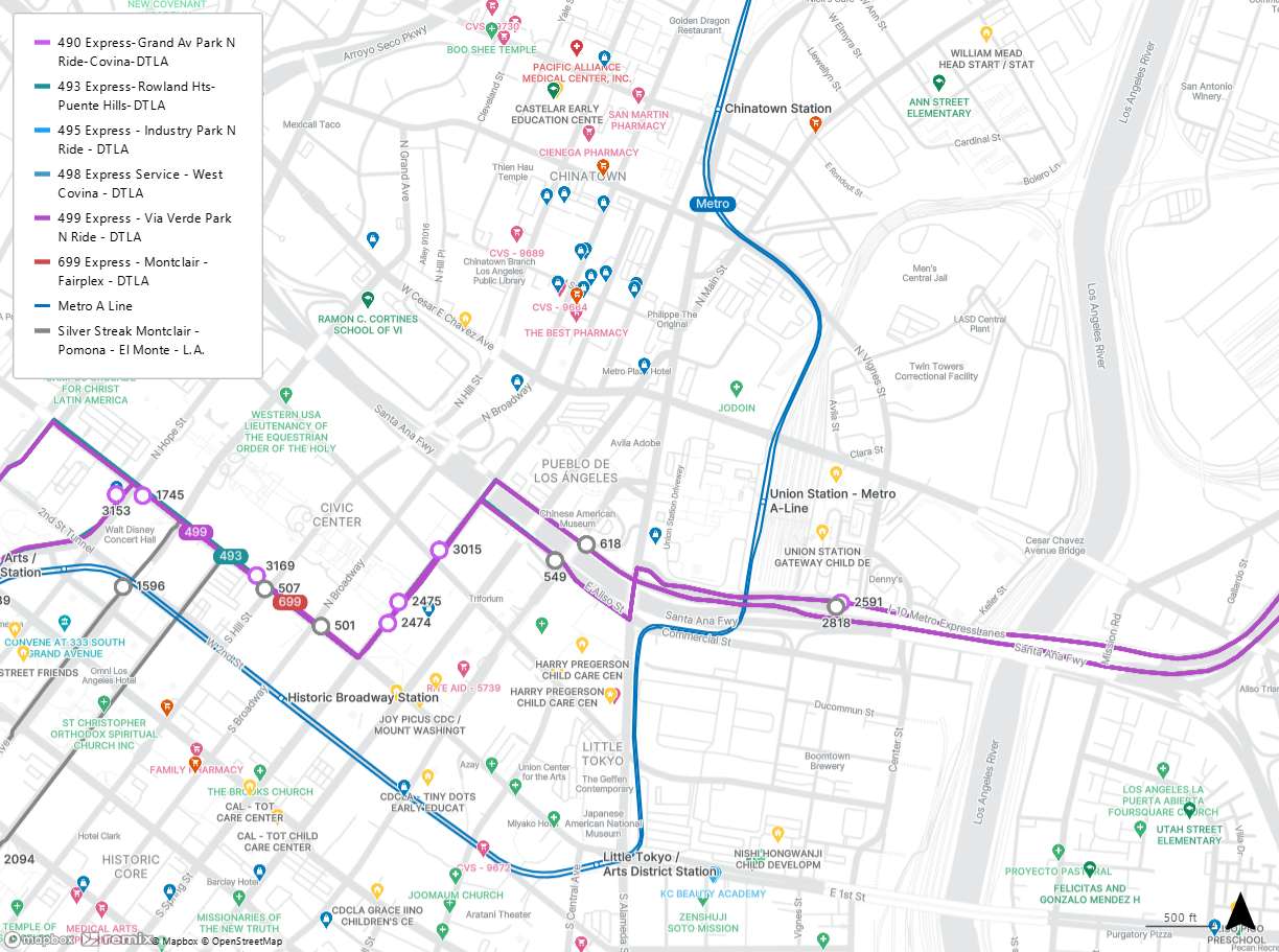
Union Station is at Alameda St south of Cesar E Chavez Ave in downtown Los Angeles.
While you’re here, see El Pueblo de Los Ángeles Historical Monument, stroll the shops on Olvera St, and visit the Italian American Museum of Los Angeles.
Connect with the Silver Streak and Lines 490, 493, 495, 498, 499, and 699 at Union Station Patsaouras Bus Plaza.
The Silver Streak serves Montclair, Pomona, West Covina, Baldwin Park, El Monte, and Los Angeles 24 hours a day, seven days a week. Popular destinations include Cal Poly Pomona and Plaza West Covina. Lines 490, 493, 495, 498, 499, and 699 travel into downtown Los Angeles on weekday mornings and back east on weekday evenings. Line 490 serves Glendora and Covina, including Glendora Promenade. Line 493 serves Rowland Heights and City of Industry, including Schabarum Park. Line 495 serves City of Industry. Line 498 serves West Covina. Line 499 serves the Via Verde Park & Ride. Line 699 serves Montclair and Pomona.
7. Del Mar Station
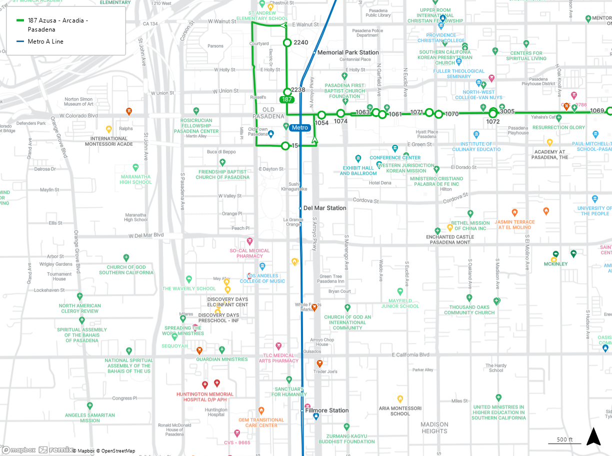
The Del Mar Station is at Del Mar Blvd and Arroyo Pkwy in Pasadena.
While you’re here, stroll through Central Park, grab a burger at Lucky Boy, and dazzle yourself with the shopping in Old Pasadena.
Connect with the Line 187 at Green St and Raymond Ave or Raymond Ave and Union St.
Line 187 is our most popular local line, with buses every 15 to 30 minutes all week serving Pasadena, East Pasadena, East San Gabriel, Arcadia, Monrovia, Duarte, Irwindale, and Azusa. Destinations include Pasadena City College, The Shops at Santa Anita, Santa Anita Race Track, Old Town Monrovia, City Of Duarte Parks And Recreation Department, Costco, and the Santa Fe Dam Recreational Area.
8. Memorial Park Station
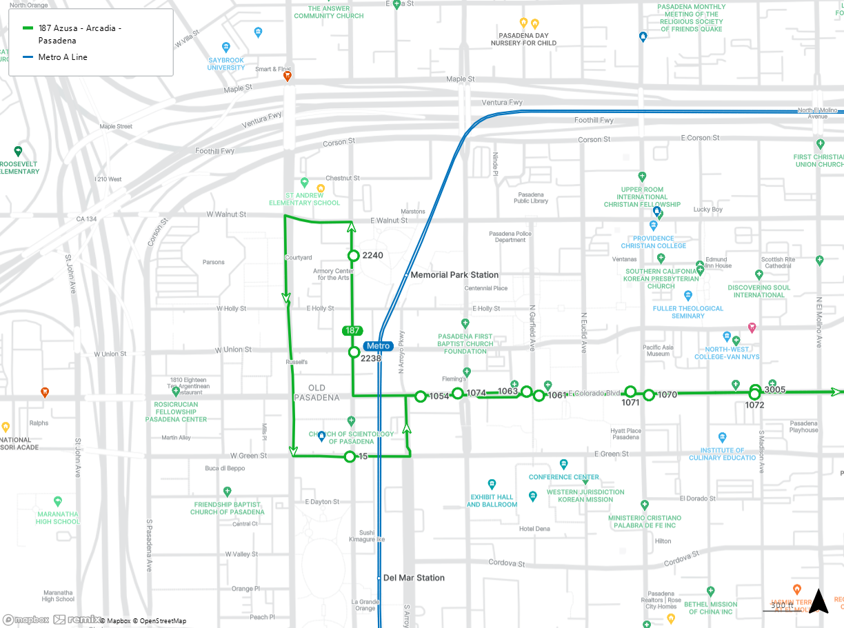
The Memorial Park Station is at Holly St and Raymond Ave in Pasadena.
While you’re here, stroll through Memorial Park, enjoy the Armory Center For the Arts, and pose for a photo in front of the picturesque Pasadena City Hall.
Connect with the Line 187 at Raymond Ave and Walnut St.
Line 187 is our most popular local line, with buses every 15 to 30 minutes all week serving Pasadena, East Pasadena, East San Gabriel, Arcadia, Monrovia, Duarte, Irwindale, and Azusa. Destinations include Pasadena City College, The Shops at Santa Anita, Santa Anita Race Track, Old Town Monrovia, City Of Duarte Parks And Recreation Department, Costco, and the Santa Fe Dam Recreational Area.
9. Sierra Madre Villa Station
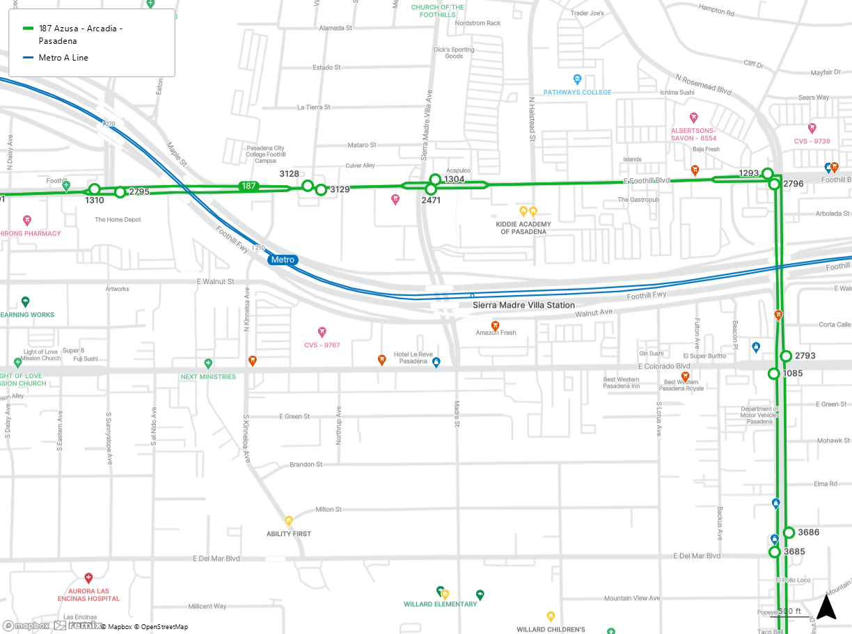
The Sierra Madre Villa station is at the 210 Freeway and Sierra Madre Villa Ave.
While you’re here, enjoy live theatre at A Noise Within, check out the shopping at Hastings Village, or bowl a strike at Bowlero.
Connect with Line 187 at Foothill Blvd and Sierra Madre Villa Ave.
Line 187 is our most popular local line, with buses every 15 to 30 minutes all week serving Pasadena, East Pasadena, East San Gabriel, Arcadia, Monrovia, Duarte, Irwindale, and Azusa. Destinations include Pasadena City College, The Shops at Santa Anita, Santa Anita Race Track, Old Town Monrovia, City Of Duarte Parks And Recreation Department, Costco, and the Santa Fe Dam Recreational Area.
10. Arcadia Station
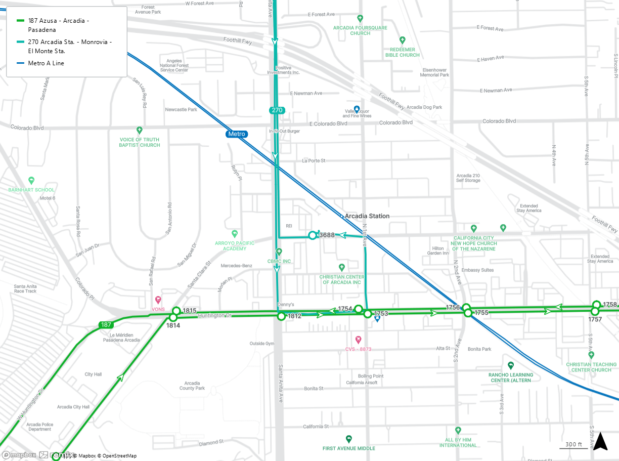
The Arcadia station is at 1st Ave and Santa Clara St in Arcadia.
While you’re here, climb to the top at Hangar 18, get hyper at Hyper Coffee, and explore Arcadia County Park.
Connect with Line 270 at Arcadia Station.
Line 270 serves Arcadia, Monrovia, South Monrovia Island, Mayflower Village, Irwindale, and El Monte. Destinations include Old Town Monrovia, Peck Road Water Conservation Park, Santa Fe Historical Park, and the Rio Hondo Bike Path.
11. Monrovia Station
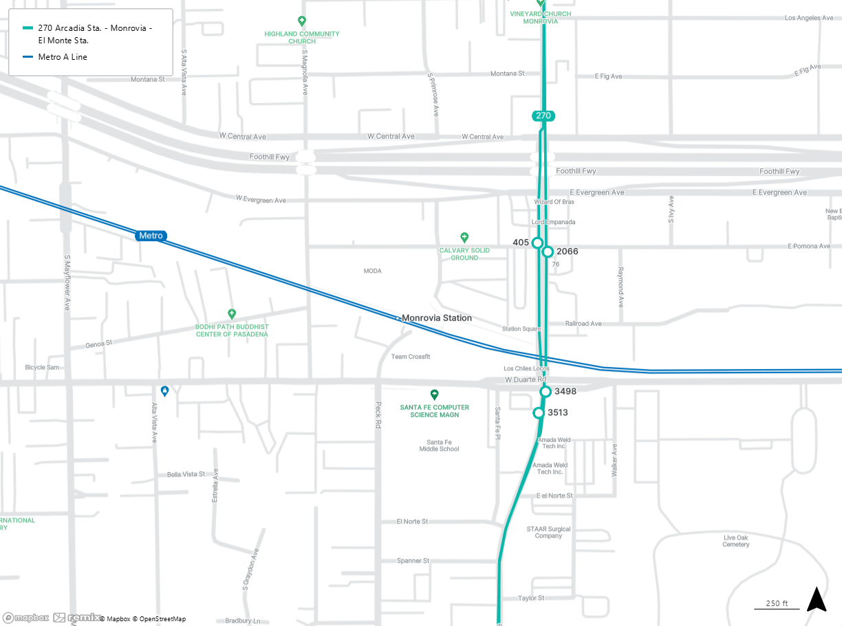
The Monrovia station is at Duarte Rd and Peck Rd in Monrovia.
While you’re here, relax at Monrovia Station Park, comfort yourself with diner food at Nano Cafe, or try a selection of Argentine empanadas at Lord Empanada.
Connect with Line 270 at Myrtle Ave and Duarte Rd.
Line 270 serves Arcadia, Monrovia, South Monrovia Island, Mayflower Village, Irwindale, and El Monte. Destinations include Old Town Monrovia, Peck Road Water Conservation Park, Santa Fe Historical Park, and the Rio Hondo Bike Path.
12. Duarte/City of Hope Station
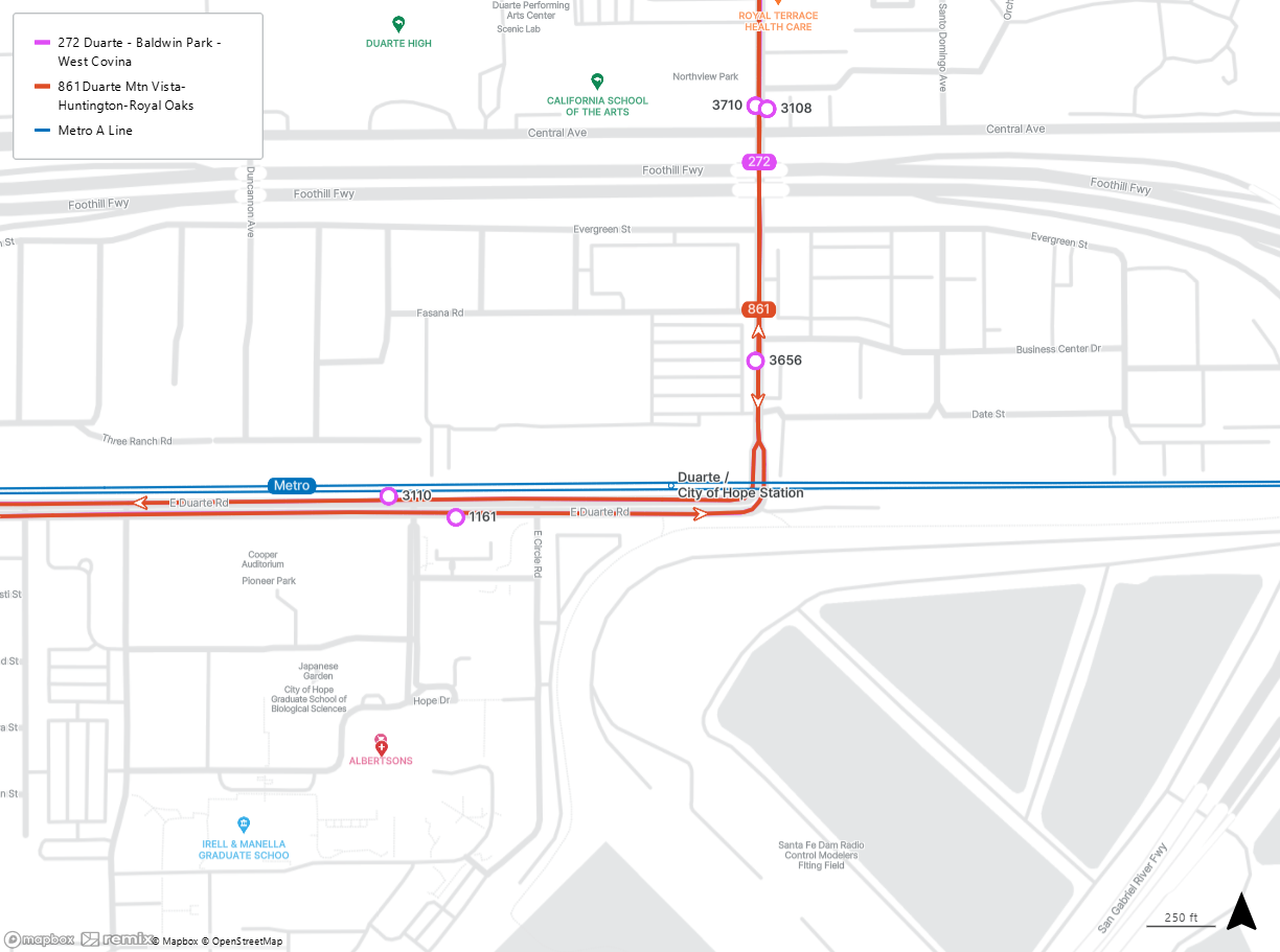
The Duarte/City of Hope Station is at Duarte Rd and Highland Ave in Duarte.
While you’re here, work on your skills at Duarte Skate Park, bike the San Gabriel Valley River Trail, or donate blood at City of Hope.
Connect with Line 272 and Line 861 at Duarte Rd and Hope Dr.
Line 272 serves Duarte, Irwindale, Baldwin Park, and West Covina. Destinations include Baldwin Park Senior Center, Citrus Valley Medical Center - Queen Of The Valley Campus, and Plaza West Covina. Line 861 serves Duarte, Monrovia, South Monrovia Island, Irwindale, and Azusa. Destinations include Mountain Vista Plaza and Encanto Park.
13. Irwindale Station
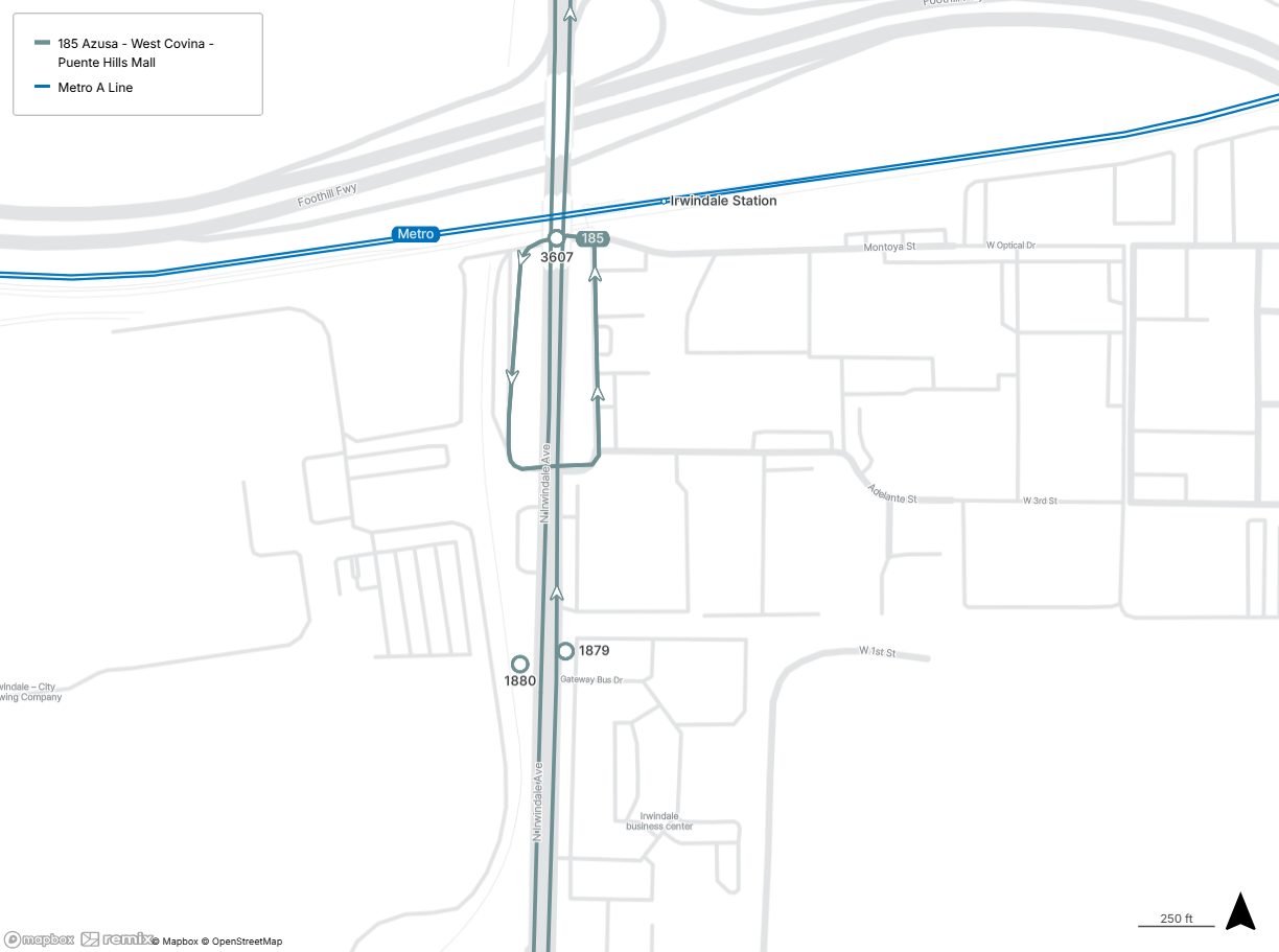
The Irwindale station is at Irwindale Ave and Avenida Padilla in Irwindale.
Connect with Line 185 at the Irwindale Station stop.
Line 185 serves Azusa, Irwindale, Vincent, West Covina, Valinda, La Puente, City of Industry, and Hacienda Heights. Destinations include Costco, Santa Fe Dam Recreation Area, Plaza West Covina, La Puente Live Farmers Market, Workman And Temple Family Homestead Museum, and Schabarum Regional Park.
14. Azusa Downtown Station
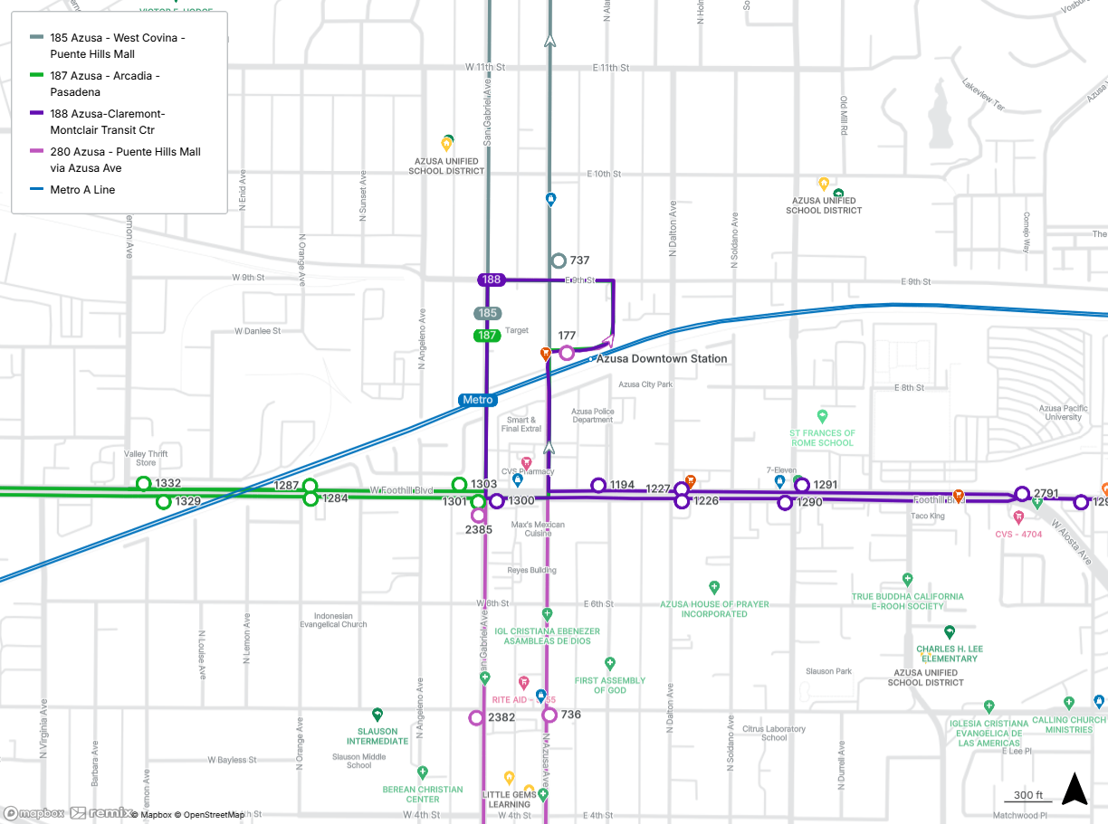
The Azusa Downtown station is located at 9th St and Alameda Ave in Azusa.
While you’re here, get a cup of joe at Flo’s Coffee Shop, una taza de café at Café Cultura, or some Mediterranean food at Lemón Zëst.
Connect with Line 185 at Foothill Blvd and San Gabriel Blvd and Lines 187, 188, and 280 at the Azusa Intermodal Transit Center.
Line 185 serves Azusa, Irwindale, Vincent, West Covina, Valinda, La Puente, City of Industry, and Hacienda Heights. Destinations include Costco, Santa Fe Dam Recreation Area, Plaza West Covina, La Puente Live Farmers Market, Workman And Temple Family Homestead Museum, and Schabarum Regional Park. Line 187 is our most popular local line, with buses every 15 to 30 minutes all week serving Pasadena, East Pasadena, East San Gabriel, Arcadia, Monrovia, Duarte, Irwindale, and Azusa. Destinations include Pasadena City College, The Shops at Santa Anita, Santa Anita Race Track, Old Town Monrovia, City Of Duarte Parks And Recreation Department, Costco, and the Santa Fe Dam Recreational Area. Line 188 serves Montclair in San Bernardino County, Claremont, Pomona, La Verne, San Dimas, Glendora, and Azusa. Line 280 serves Azusa, Covina, West Covina, Valinda, La Puente, South San Jose Hills, and City of Industry. Destinations include Schabarum Regional Park.
15. APU/Citrus College Station
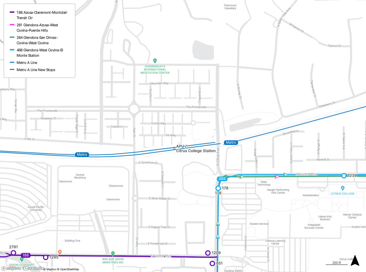
The APU/Citrus College station is located at Palm Dr and 9th St in Azusa.
While you’re here, enjoy 10 Arroyo South Park and take in a performance at the Haugh Performing Arts Center.
Connect with Lines 188, 281, 284, and 488 at Foothill Blvd and Citrus Ave.
Line 188 serves Montclair in San Bernardino County, Claremont, Pomona, La Verne, San Dimas, Glendora, and Azusa. Line 281 serves Glendora, Azusa, Citrus, Covina, West Covina, West Puente Valley, La Puente, City of Industry, and Hacienda Heights. Destinations include Eastland Center, Plaza West Covina, Queen of the Valley Hospital, and the Schabarum Regional Park. Line 284 serves Glendora, Azusa, San Dimas, Charter Oak, Covina, and West Covina. Destinations include Sam’s Club, Costco, YMCA San Gabriel Valley, and Eastland Center. Line 488 serves Azusa, Glendora, Covina, Charter Oak, West Covina, Valinda, La Puente, West Puente Valley, Baldwin Park, Irwindale, and El Monte. Destinations include YWCA, Eastland Center, YMCA, and Santa Fe Historical Park.
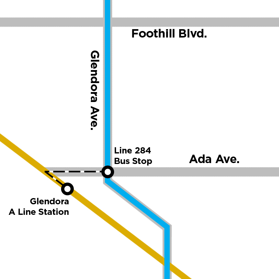
16. Glendora Station
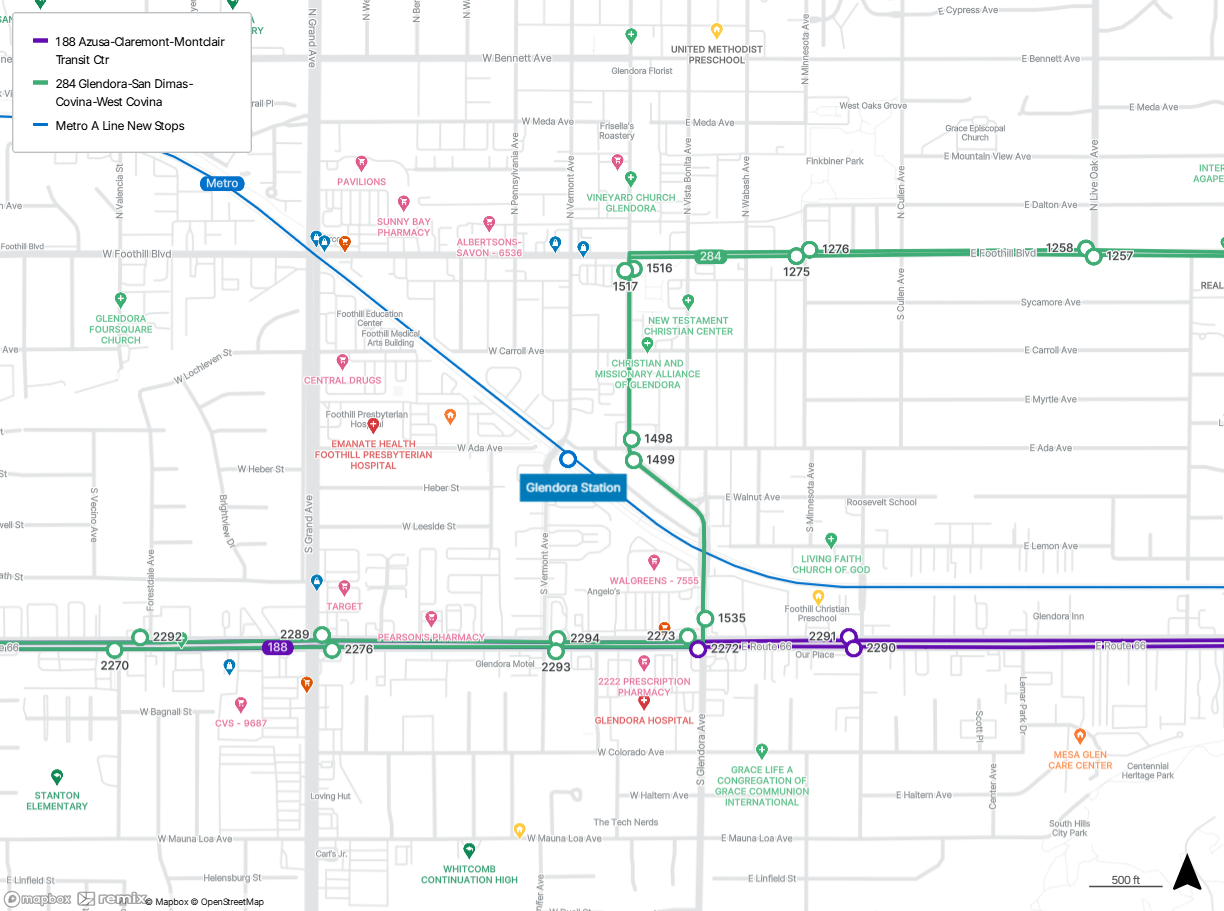
The Glendora station is located at Vermont Ave and Ada Ave in Glendora.
While you’re here, browse New Unto Others Thrift Store, check out Big Tree Park, and sit and sip in Classic Coffee.
Connect with Line 188 at Route 66 and Vermont Ave and Line 284 at Glendora Ave and Ada Ave.
Line 188 serves Montclair in San Bernardino County, Claremont, Pomona, La Verne, San Dimas, Glendora, and Azusa. Line 284 serves Glendora, Azusa, San Dimas, Charter Oak, Covina, and West Covina. Destinations include Sam’s Club, Costco, YMCA San Gabriel Valley, and Eastland Center.
17. San Dimas Station
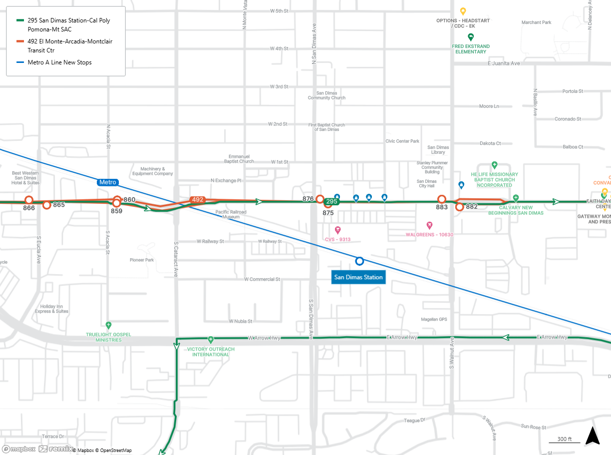
The San Dimas station is located at San Dimas Ave and Bonita Ave in San Dimas.
While you’re here, visit Civic Center Park.
Connect with Lines 295 and 492 at Bonita Ave and San Dimas Ave.
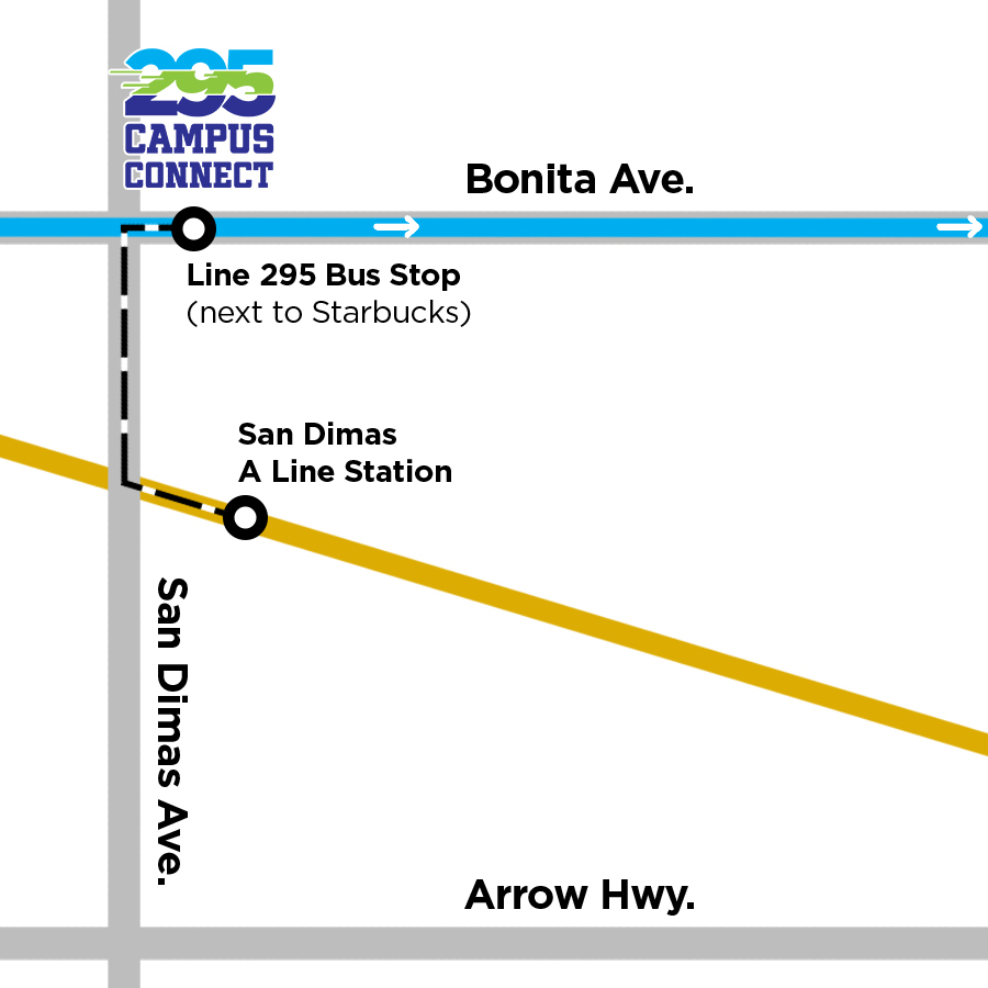
Line 295 serves San Dimas, Pomona, and Walnut. Destinations include Cal Poly Pomona and Mt. San Antonio College. Line 492 serves El Monte, Temple City, North El Monte, Arcadia, Mayflower Village, Irwindale, Baldwin Park, Azusa, Vincent, Covina, Glendora, Charter Oak, San Dimas, La Verne, Pomona, Claremont, and Montclair. Destinations include Santa Fe Historical Park, Sam’s Club, Santa Fe Dam Recreational Area, University of La Verne, and Montclair Place.
18. La Verne/Fairplex Station
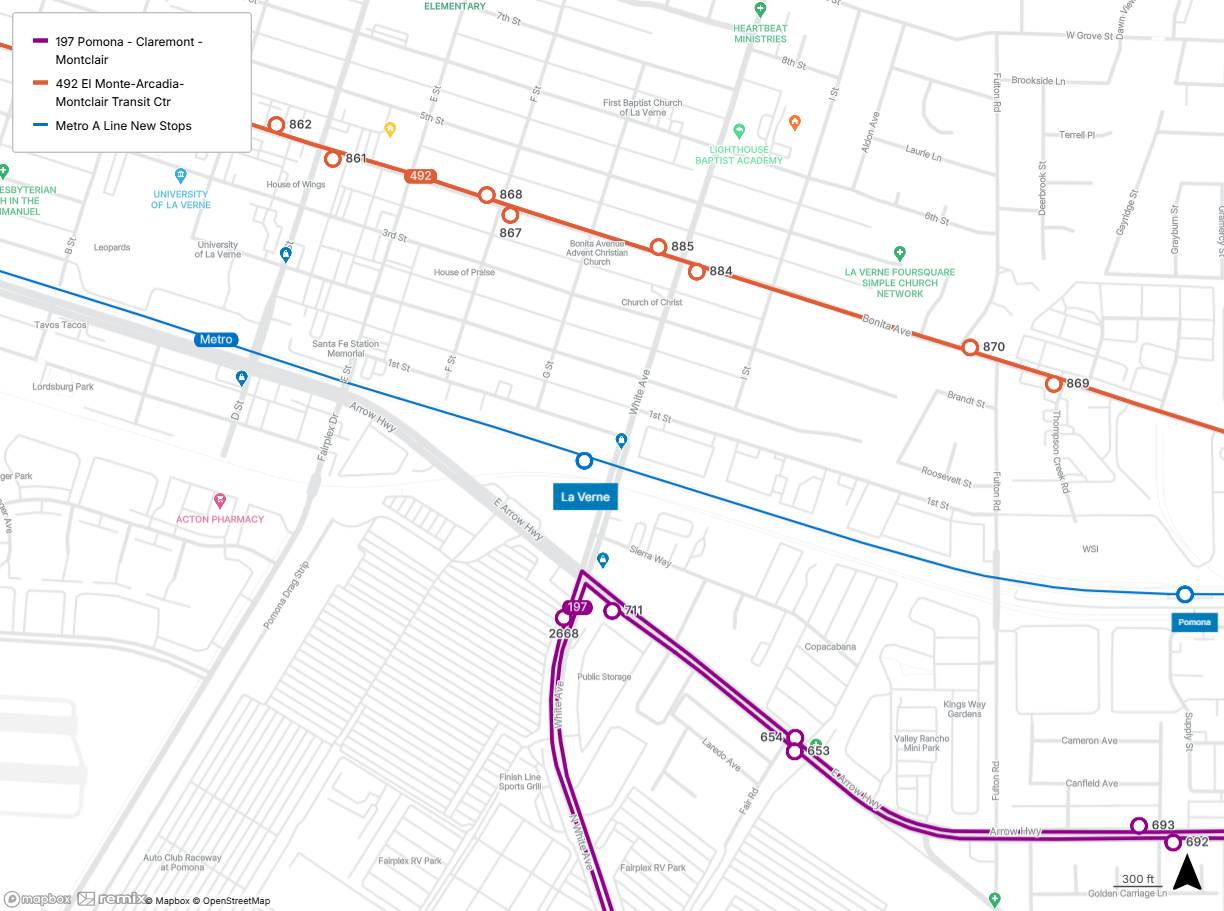
The La Verne/Fairplex station is located at White Ave and 1st St in La Verne.
While you’re here, visit Nambah Coffee Co.
Connect with Line 197 at Arrow Hwy and White Ave and Line 492 at Bonita Ave and White Ave.
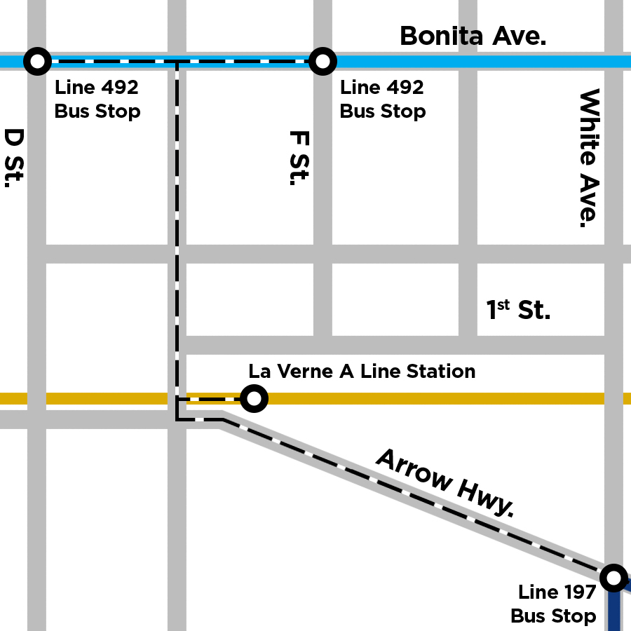
Line 197 serves Pomona, La Verne, Claremont, and Montclair. Destinations include School of Arts and Enterprise, Downtown Pomona Farmers Market, Frank G. Bonelli Regional Park, and Pomona Fairplex. Line 492 serves El Monte, Temple City, North El Monte, Arcadia, Mayflower Village, Irwindale, Baldwin Park, Azusa, Vincent, Covina, Glendora, Charter Oak, San Dimas, La Verne, Pomona, Claremont, and Montclair. Destinations include Santa Fe Historical Park, Sam’s Club, Santa Fe Dam Recreational Area, University of La Verne, and Montclair Place.
19. Pomona North Station
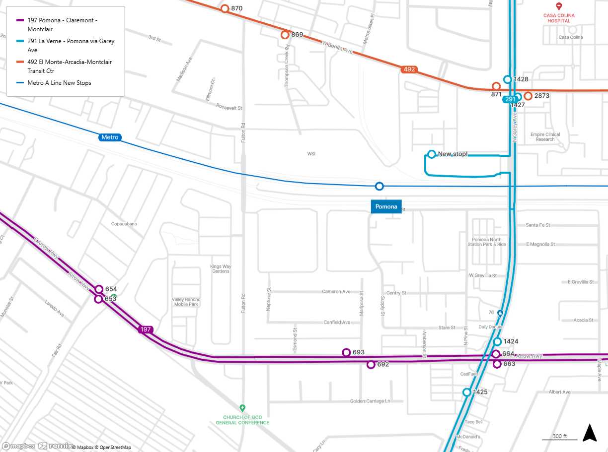
The Pomona North station is located at Garey Ave and Bonita Ave in Pomona.
While you’re here, hit some balls at JB Athletics.
Connect with Line 197 at Arrow Hwy and Garey Ave, Line 291 at the Pomona Station stop, and Line 492 at Bonita Ave and Garey Ave.
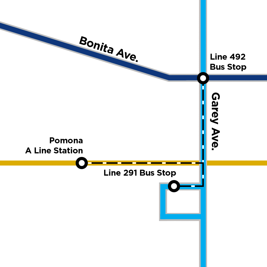
Line 197 serves Pomona, La Verne, Claremont, and Montclair. Destinations include School of Arts and Enterprise, Downtown Pomona Farmers Market, Frank G. Bonelli Regional Park, and Pomona Fairplex. Line 291 serves La Verne and Pomona. Destinations include La Verne Library, School of Arts and Enterprise, Downtown Pomona Farmers Market, and Civic Center Plaza. Line 492 serves El Monte, Temple City, North El Monte, Arcadia, Mayflower Village, Irwindale, Baldwin Park, Azusa, Vincent, Covina, Glendora, Charter Oak, San Dimas, La Verne, Pomona, Claremont, and Montclair. Destinations include Santa Fe Historical Park, Sam’s Club, Santa Fe Dam Recreational Area, University of La Verne, and Montclair Place.
How do I transfer between Metro rail and Foothill Transit buses?
All you have to do is pay your fare with your TAP card. When you tap your card again at your second boarding (within two and a half hours), you’ll automatically be charged the transfer fee instead of the full fare. You’ll need stored value on your card to pay the transfer fare. Without a TAP card, you’ll have to pay full fare.
Foothill Transit passes are only accepted on our buses*. EZ Transit passes are good for multiple agencies.
*With one exception: you can use your Foothill Transit pass to board the Metro J Line from El Monte Station through downtown Los Angeles with our Silver Streak to Metro J Line program.


